Reading a Karakoram Glacier: What the Surface Is Telling You
First-time visitors to the Baltoro are often quietly disappointed. They expected white ice. What they get is a grey river of stone, so thoroughly buried under rubble that for long stretches you would not know you were on a glacier at all, except that the ground keeps making noises.
That debris cover is the first thing worth understanding, because almost everything else follows from it.
Why it is covered in rock
The Karakoram is steep, young and actively falling apart. Its walls shed rock continuously onto the ice below, and because the range is so vertical relative to the glaciers draining it, the supply is enormous. The result is a debris-covered glacier: ice underneath, a metre or more of rock on top.
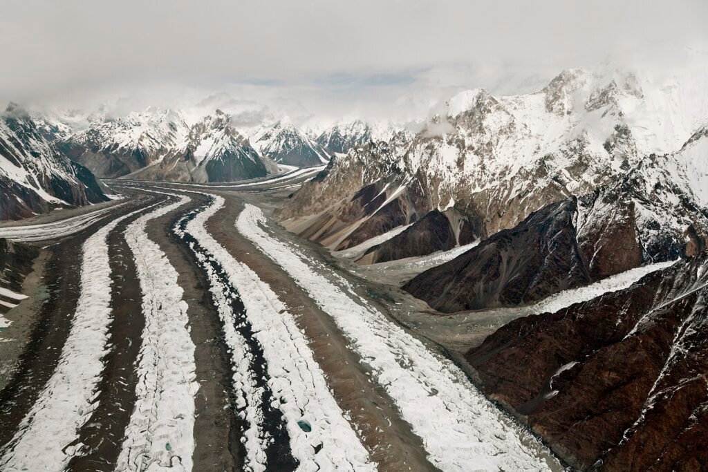
That blanket insulates the ice. A clean glacier melts under sunlight; a debris-covered one is partly protected, which is one reason Karakoram glaciers have behaved differently from the global pattern of retreat. The stripes running down the glacier are medial moraines, formed where two tributary glaciers merge and their side-debris is squeezed into a line. At Concordia several of these converge at once, which is why the surface there reads like a braided road.
The surface is moving
Under the rubble, the ice is flowing, and the surface reflects it. Expect ice cliffs that appear where the debris has slid off and bare ice is melting fast, and expect them to change between your walk in and your walk out.
Supraglacial ponds form in hollows, sometimes a startling turquoise, and they drain abruptly when the ice below opens a channel. Do not camp beside one on the assumption that it is a lake. It is a temporary hole with water in it.
Everywhere you will hear the glacier working: a knock of falling stone, the distant collapse of an ice face, running water somewhere beneath your boots. That noise is normal. What matters is direction and proximity.
Crevasses under rubble
On the main body of the Baltoro the trail is generally well established and crevasses are visible where they occur. The hazard changes as soon as you leave the trodden line, or move onto snow-covered ice higher up, where a crevasse can be bridged by snow strong enough to hold nothing at all.
Crevasses form where the ice is stretched: on the outside of bends, where the bed steepens, and where tributaries join. Reading those stresses tells you where to be careful even when the surface looks uniform. Rope up on snow-covered glacier, follow your guide’s line on rubble, and treat any unusual dip or sag in the snow as a question rather than a shortcut.
Ablation, and why the trail changes
Through the summer the glacier surface lowers as it melts, unevenly, depending on how thick the debris is at each point. A route that was flat in June can be a series of ridges and troughs by August. Guides re-find the line every season, and sometimes every week.
This is also why distances on the Baltoro are misleading. The map says a modest number of kilometres. The ground says up, down, around, and over, all day, on ankle-turning stone.
What to actually do with this
Walk where your guide walks, particularly near ice cliffs and stream margins. Look up occasionally, especially under steep walls in the afternoon when the sun has been working on them. Do not camp beneath an ice cliff, beside a meltwater channel, or in the mouth of a side valley that has obviously delivered debris before.
Poles help more here than on any trail, because the surface is unstable and each step is slightly different. Boots take a beating; this terrain destroys worn soles faster than anything else on the trip. Our cost guide covers why replacing them beforehand is cheaper than discovering the problem at Urdukas.
And it is worth simply stopping now and then to look at what you are standing on. This is one of the largest glacier systems outside the polar regions, and the fact that it looks like a builder’s yard rather than a postcard is the most interesting thing about it. The reporting collected at ExplorersWeb tracks how quickly these surfaces are now changing from season to season.